Tuesday, June 26, 2007

Crystal 6-26-07

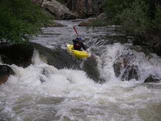
After a day on the Roaring Fork, we decided to check out the Crystal in the next valley over. I was hoping to run Crystal Mill Falls, but it really didn't look good. The preferred line is right. Unfortunately there is a jagged outcropping creating a curling boil. This boil pushes straight into the center left seam where you don't want to be. Maybe it goes easier with more water?


Since we were up there we ran the short section below Crystal Mill. We knew it probably would not be very good but we went anyway. There is one significant drop on this section. It is a 6 footer that strongly resembles a lowhead dam. There is a 10-15 foot recirculation that is worse on the left. Looking down from above.


I ran right, got no boof off the shallow shelf, and paddled out of the backwash. Brian did the Class V portage on the left.


Basically the run was Class III with some wood and a scary hydraulic. I doubt I'll do this one again. We ran Crystal Narrows on the way out of the canyon. The scenic and enjoyable Narrows:

Castle Creek/Slaughterhouse 6-25-07

We headed out to the Roaring Fork Valley on Monday to get the last of their snowmelt. The Slaughterhouse gauge was at 750 cfs. There is no Castle Creek gauge so we just checked it out visually. It looked like 200+ cfs which we hoped would be enough. Castle Creek has several small Boulder gardens with blind corners. This combined with its reputation for accumulating wood led to a handful of scouts.

Typical Castle Creek scenery- small boulder garden with an almost river-wide log.


Bigger boulder garden downstream.


After a few miles on Castle Creek, we joined the Roaring Fork for the Slaughterhouse run. Slaughterhouse Falls is the most significant drop in this section. It is a 5 foot ledge than can be run cleanly on the left. Brian running Slaughterhouse Falls.


The rest of the run is mellow boulder gardens.


One thing to note about these runs is that the riverbed of both is entirely smooth, round boulders, which is a nice change from the Front Range. For future trips, I think 1500+ on the Slaughterhouse gauge would be ideal.

Bailey 6-24-07

We put on Bailey with 500cfs at the put-in and 650 at the takeout. Out of the many time I have paddled Bailey, this was the highest water level. I thought the run was much higher quality than low water Bailey and not much harder (except for Supermax). We had six in our group and another three were with us for most of the day. Despite the group size, everything went pretty smoothly (except for three swims by paddlers who will remain nameless).

Second Falls.


Third Falls.


Supermax is alot harder at high water. The line is extremely thin. Nobody ran the whole thing today. Ian runs the sneaky-sneak line at Tampax.


Deer Creek is one of the few places on the run where higher water noticably increases difficulty. Its pushy at this level but it all goes straight down the main current. A rare shot of myself in the Deer Creek crux.


Deer Creek crux from below.


Ian performed a heroic rescue of a paddle that had lost its owner and become pinned in the Mystery Eddy rapid.

Saturday, June 23, 2007

Poudre Play Run 6-23-07

The Poudre Play run is the Upper Mish/Lower Mish/Poudre Park/Bridges combo. It sounds like alot, but it only takes a couple hours. The general rule for this run is that more water is always better. We had 3.7 feet on the Pineview Gauge (med-high) on sunny and warm June day.

Somewhere is Upper Mish.


Cool little boof drop in Upper Mish:


"Cardiac Corner" I think:


Pinview Falls is the best rapid on the run, so naturally the commercial rafting companies portage it?!? Egan in the top half of the rapid:


And the bottom:

Tuesday, June 19, 2007

Upper Clear Creek 6-19-07

I have to admit I was not too impressed by this run the first time I did it (at some piddly little water level). What a difference high water makes. At 900 cfs it is good afterwork fun.

The first couple ledgy drops are actually more straightforward at this level (but they are much steeper than they appear in these pictures).


Dropping into one of the ledges from above.


After a little boogie, you come to Double Knife, which has more gradient than any other rapid on the run. There is a log left-center in the entrance followed by a huge pour-over on the right, but a simple right to left move avoids both hazards.


After Double Knife, its just read and run hole bashing to the takeout.

The Numbers 6-16/17-07

After the scary pin experience on Clear Creek, I was ready to paddle something with no pin spots, and the Numbers fit the bill. At 1500 cfs, I was actually surprised by how mellow this run is. But its fun and worth doing. Bring your playboat. On Sunday, we came back and did Pine Creek and the Numbers. This adds some more good whitewater to an otherwise quick run.

Beau entering Number 5 Rapid.


#5 from below.

Clear Creek of the Ark 6-16-07

Fibark weekend on the Ark with perfect weather and good flows- this is why we live in Colorado. If you can't find beautiful free camping in the Arkansas valley, you need to have your vision checked out.


On Saturday morning everyone and their brother showed up to run Clear Creek of the Ark. Pre-scouting the gorges from the road is a popular (and wise) option.


We had about 300 cfs. I expected this flow to fill in the small creekbed pretty well. I was surprised with how bony and not pushy the creek still was. More water would definitely be good.

The first gorge was good fun and had some strategically placed wood.


Exit from the first gorge.


The first run went super smooth, so we went up for another. On the second run, a member of our group experienced a scary underwater pin on the rock in the center of this rapid, which comes up quickly after the first gorge. Due to this pin, the paddler was forced to abandon his personal watercraft and his paddle. Said watercraft was then Z-dragged off the rock and the paddle is gone. In case you are wondering, the line is to follow the main flow RIGHT of the rock.


Scenic tributary waterfall visible from the takeout.

Wednesday, June 13, 2007

NSV Proving Grounds

The Proving Grounds is a short canyon section of lower North Saint Vrain Creek. It has two IV+ to V rapids and some boogie rapids in between. We had about 210 cfs. This seemed like the lower end of doability. I would want at least 50 more cfs before I do it again. The first rapid is the biggest. Marty scouts the burly/seive center line:


Darren runs the top portion of the right line.


The second rapid is by far the high point of the run. Its twisy, turny, fast, and fun. Darren in the second half of the rapid:


Towards the end of the run, a local landowner has chopped down a large tree across the river forming death trap for boaters. It will be even more dangerous with higher water. He has been apprised of the situation and his response is the yellow caution sign on the tree. This sign is apparently designed to give a paddler 2-3 seconds of warning before he or she is stuffed under the log.


Dr. Booth explains how the log is not really a hazard for kayakers who are less than 14 inches tall. Note the freshly cut stump.

Monday, June 11, 2007

Lower Boulder Canyon 6-11-07

Lower Boulder Canyon is a quickie before work/lunch/after work run for Boulder locals. The photos here are from a minimum fun level of 250 cfs (once a again, water drops on the lense were an issue). The creek boogies for the first couple miles before rounding the corner and dropping into Elephant Buttress Rapid. The bottom of the rapid:


Shortly after Elephant Buttress, the creek enters town and the "playpark" begins. Andy on the slide in the playpark during a recent lunchtime run:

Sunday, June 10, 2007

Dumont 6-10-07

Dumont is a fun Class IV run on upper Clear Creek. It is further up the creek than the other commonly run sections, so the water is chilly even on a sunny day. We ran it today at 600 cfs which is an okay flow but more would be better. I somehow managed to take every single picture with a water drop on the lense.

The first mile or so is a continuous wave train with a few holes sprinkled in.


Ladies love continuous whitewater.


There is a section of artificial ledges after the wavetrain ends. There are a few holes but none are keepers. The Count lines up on one of them.


Some other rapid further down.


Halfway down one of the last rapids.

Wednesday, June 6, 2007

Lyons Outdoor Games

The Lyons Outdoor Games are going down Saturday, June 9th in Lyons, CO. With everything from a Class V race to rodeo competitions to a dog competition, its going to be a good time for all. On that note, I thought I'd post a couple playboating pictures from the 3 features in town on the main Saint Vrain. These photos were taken at about 300 cfs. We are hoping for 400-450 this weekend.

The Black Bear Hole:


The A-hole:


And the October Hole:

Lower Clear Creek 6-6-07

Lower Clear Creek is a nice little Class IV run just outside of Golden. The riverbed is all blasted road rock so its sharp and jagged. But when the water gets high, the ugly riverbed gets covered up and the creek becomes nonstop waves and holes. The pictures here show the creek at about 800 cfs. We ran it this evening at 950 and eveybody agreed it was a good time.

The last half mile above the nasty diversion dam is affectionately referred to as the Screaming Quarter Mile. Here is the entrance:


The middle part of the SQM. The first ledge that is visible has a great boof on the left.


As the SQM winds down, its time to find a eddy (don't be too picky) and portage the diversion dam. As usual, this picture makes it look much better than it looks in person. There is a fine line on the right that can be run, but take a good look at those holes before committing.